USASTRATCOM

This blog was created for USASTRATCOM Long Lines Battalion Army personnel who served in Taiwan during the 1965-72 time frame. Specifically, those who lived and worked in and around Taipei are the target. If you worked at the Grass Mountain or Gold Mountain facilities or anywhere in downtown Taipei, we would like to hear from you. All are welcome to visit and contribute to this blog. Your comments and pictures are encouraged.

Tuesday, December 18, 2012

Going To Grass Mountain, 1957-58, Taipei Taiwan

The transmitter site where Tom Jones worked was directly connected to the Sugar Building by cable. A receiver site on Grass Mountain was also in the mix in 1957. This post contains some unique photos of the Yangmingshan area.

In addition, we have some communications basics on signal transmission in the 1950s and later. Taiwan came a long way in a short time to become current with available technology. The Signal Corps led the way. 

Photo courtesy of Tom Jones

Winding its way northward is Chung Shan North Road  from downtown Taipei to Grass Mountain and other areas.

Photo courtesy of Tom Jones

This picture wasn't going to be included, but the Taiwanese who commented on it seemed fascinated.

They argued among themselves as to whether this picture was taken in Shilin near Chiang Kai-shek's residence, or whether it just had something to do with Double Ten Day.

Again, we're leaning on Kent Mathieu of TaipeiAirStation.blogspot.com, who visited President Chiang's Shilin residence in 2010. View Kent's beautiful posting by clicking HERE.
Photo courtesy of Tom Jones

Although beautiful in the distance, the two lane paved road to Grass Mountain could be hazardous. Not only were guard rails missing, but overhead road lights were non-existent when Tom took this picture.

Shortly after we arrived in 1968, Taiwanese laborers hand-dug a trench all the way from Taipei up the mountain to President Chiang's summer residence. Electrical lines were buried after being connected to vapor lights.
Photo by Gary Wilson; Courtesy of TaipeiAirStation.blogspot.com

This photo has been used before in another post, but it shows exactly how the road to Grass Mountain was so treacherous at times.

With corkscrew turns and no lights illuminating the road, an overcrowded bus was a prime candidate for an accident. 

Here is a cut and paste picture of the Grass Mountain work site in 1969.  Whether it was the receiver site that Tom used is not known. 

In fact, it is not known to me when the Grass Mountain, Gold Mountain JOSS, and Seven Star facilities were constructed. 
Photo courtesy of Scott Ellinger

When the Army began its long-term commitment to Taiwan during the Korean War and afterward, facilities such as the Seven Star Microwave site were being constructed in several places in Taiwan. 

Since this was an Army undertaking, it was under the authority and control of MAAG-Taiwan..  As can be seen, the front of Seven Star in this picture indicates it was a "Scatter Station." To see what that means, click HERE.

From what I've read, STARCOM Army communications was a network of interconnected teletype sites around the world. The Seven Star Scatter Station shown in the picture above was not yet part of a satellite network in the 1950s  when Tom Jones' detachment was in Taiwan. Please correct me as I'm guessing, as usual.

The escalation of the Vietnam War resulted in the mass addition of satellite send/receive stations under the USASTRATCOM banner. STARCOM was not able to keep up with the volume of messages being sent around the world via the scatter system..  

If you folks in your 60s and older ever watched The Big Picture military television show, you might be familiar with the segment we are showing. Thanks go to Army LTC Scott Ellinger who provided it. The section about Taiwan begins around minute 21. To view, just click HERE. For those of you who understand communications, this short spot about Taiwan will make sense. 


Look at the lower left part of this picture and you can see Scott Ellinger's black and white photo directly above. This picture was taken in 1969, when Seven Star was part of USASTRATCOM. This is the header photo for this blog.
Photo courtesy of Tom Jones

With water flowing down a ditch, this picture was taken long before anyone had an idea of straightening the road to President Chiang's summer residence.

The scene should look familiar to all of the hundreds of guys who made their way north to the hostel.
Photo courtesy of Tom Jones

Our blog has many pictures of this building and the many uses it has had over the last two centuries. 

When Tom Jones and his detachment went up the road to see it, the hostel shown was officially known as Hostel #3.  Military men were living there.

Hostels #1and #2 were outside the East Compound in Taipei.

Photo courtesy of Tom Jones

Tom assures us that somewhere in the background is the hostel and its surroundings.

Photo courtesy of Tom Jones

Initially, my thoughts were that this might be a hotel in Pei Tou (Beitou) since the open sulphur spring has a decent sized building in the background. 

Our blog auditor provided a literal translation and the building is not a hotel nor is it in Beitou.  It was probably near the hostel and it says "Chiang Kai-shek Long Life Hall." 

Photo courtesy of Tom Jones

Anyone who lived in the hostel on Grass Mountain knew that the village of Beitou was not too far away.  It looks pretty lush doesn't it?

This picture shows the beautiful Hushan Road which ran from near the hostel to the village of Beitou.  It was still an attractive road in 1968 as it had many turns with stunning views. 

Today, the road has been straightened and is still attractive, but somewhere much of the ambiance has been lost.

Monday, December 10, 2012

Working In The Rice Paddies, 1957-58, Taipei, Taiwan

Chauffeured by ROC drivers, Tom Jones and his fellow Signal Corps detachment friends traveled west over a bridge to the area where they worked.

As you are about to see, their transmitter site was in the middle of a rice paddy. The signal from here was relayed to the Sugar Building in downtown Taipei. At that time, the Sugar Building was the hub of Taipei communications.

The transmitter site was connected to the Sugar Building using a Spiral-4 cable and a radio link with a bunch of multiplex channels. Now, that might mean something to the tech controllers and microwave men.

Haggler's Row had not been built yet, so to say that the Sugar Building was across from it on Chung Hua Road wouldn't have meant much back then.

But saying that the Sugar Building was next to the First Company Limited might give a better idea of its location.

During the Vietnam War, the Sugar Building was headquarters for the Taipei Military Telephone Exchange.  Plunk in a $1 NT coin in a public phone, dial the exchange number, and a female with a Chinese accent would say, "Taipei Military."  You would then ask her to connect you with any military site in Taipei.  
-
Photo courtesy of Tom Jones

This was a pretty well built troop transporter.  It is a heavy duty vehicle compared to the Ford vans that we wore out. 

Behind the vehicle is what appears to be the future headquarters of USASTRATCOM in the Signal Compound east of the commercial compound which contained the theater, PX and Commissary. 
Photo courtesy of Tom Jones

This ROC Army driver was responsible for transporting the Signal Corps Detachment to its work site west of downtown Taipei.

Tom indicated that this was a 3/4 ton truck. We found most drivers to be competent, if not spectacular. Get me there; bring me home.

Photo courtesy of Tom Jones

Taken from a plane above, this picture shows the Taipei Bridge crossing the Tamsui River. The road on the right approaching the bridge is Min Chuan (Minquan) West Road. 

The area west of the bridge still was not highly developed 10 years later when our groups arrived. Today it is somewhat built up, but it remains isolated after a few miles.

Civilians had to pay a toll to cross this bridge. On the other side, our destination was the Toyota garage. It was strictly repair and maintain. No cars were being sold in Taiwan yet. Ours came from Japan via Keelung.

This is Taipei Bridge today. As you will see, it's no longer a two-lane crossing.

With a separate lane on each side for 2-wheeled vehicles and pedestrians, the bridge widens to 3 lanes maximum on each side of the double line.

Take your pick of roads to exit onto. In 1968, there was one major road on the other side to follow.

Imagine the emotions of Tom and his friends going to work the first day.

Photo courtesy of Tom Jones

Photo courtesy of Tom Jones

Photo courtesy of Tom Jones

Photo courtesy of Tom Jones

Shown here is an AN/GRC-26 2 1/2 ton radio truck with PE-95 10KW generator trailers to power the radio.

I googled this truck and generators and this one was really heavy duty. A Signal Corps museum in Ft. Gordon, Georgia contains much of this equipment. 
Photo Courtesy of Tom Jones

From this and the previous pictures, you can see why the Army communications unit was to become the USASTRATCOM Long Lines Battalion.
Photo courtesy of Tom Jones 

In the background is the transmitter building.
Photo courtesy of Tom Jones

Inside the power building were five 60KW diesel generators.  These were later replaced by a really big diesel unit after Tom left the island. 

 Do you get the feeling that Con Ed didn't service this area?

Photo courtesy of Tom Jones

Another photo taken inside the transmitter building

Photo courtesy of Tom Jones

This picture is out of sequence. It was taken later in his Taiwan tour of duty when Tom was in Matsu.

It's included here as Tom is shown repairing a Kleinschmidt teletypewriter, which took patience, knowledge, parts, and luck. We are all fortunate that Tom framed his pictures better than his friends did.
Photo by Earl Axe; courtesy of LinkouNavy.com

The blue arrow points to the famous Sugar Building near Chung Hua Road around 1970. Not only was the Taipei Military Telephone Exchange inside it, but so was AFNT, AM-1560. FM-100.1 was not active in 1958.  It was online at a later date. 

The actual street the Sugar Building was on is Hankou Street. The facility was moved to Grass Mountain in 1968. From comments on other posts, the site of the new building was near the movie theater and snack bar/bowling alley.


Taken from an area near Ximending, the Sugar Building can be seen in the distance.

When we arrived in  June of 1968, AFNT stood for Armed Forces Network Taiwan. Later it was changed to American Forces Network Taiwan as part of the AFRTS.

Photo courtesy of George Lane


Looking to the left of the First Company, you can really see a fine picture of the Sugar Building.

Friday, November 23, 2012

Four Roses Bar, Taipei, Taiwan, 1958

We all had our private places of relaxation and fellowship. Before the Vietnam War, Taipei had a few bars and clubs that were not owned nor supervised by the US military.

When this picture popped up, on went my double-billed hat and the challenge of finding its old location began.

As usual, comments from the viewers of this photo were quite helpful.

Photo courtesy of Tom Jones

Someone had given Tom the address of the Four Roses Bar. It was 21 Chung Shan (Zhongshan) North Road, Section 3, Taipei. Note the barbed wire and lack of neon.

Photo courtesy of Tom Jones

Tom has this updated picture of the present-day location. Notice the trees. We're getting closer.


Next came an address check of the Florida Bakery. It is 23-25 Zhongshan North Road, Section 3, Taipei.

This was becoming too easy to find.


Today, the bakery is no longer on the corner of Zhongshan North and Nongan Street. A 7-Eleven is situated there.


This area is familiar (almost hallowed) ground for all of us who spent any time in downtown Taipei.

The Florida Bakery can be seen at the far left.

Next to it in 1968-71 (at least) were the OK and Suzie Wong Bars, standing side-by-side. Anyone on R and R during that time can relate.

So here is the Florida Bakery near the intersection of Nongan Street and Zhongshan North Road.

Today, all of the bars that once occupied much of the area south of the bakery have been replaced by a succession of bridal shops. Are you noticing the irony?
 

Here is the area once home to the Four Roses Bar.

Cherry Ho went to the effort of dodging traffic to line up the picture.

My attempts to contact Cherry Ho have not met with success. Regardless, grateful former military men say "Thank you, Cherry Ho!"

Kent Mathieu has taken many walking tours of Taipei and the surrounding area since 2010. On this one, at about 4:30 on the timer, he passes right by the old bar area. Also included is the Florida Bakery.

Just click HERE and begin the 10 minute journey, starting at the intersection of Zhongshan North and Minquan East/West looking at the old King's Hotel and 77 Club. Kent's videos can be found on YouTube under hawaiikent.


Sure, the bar is gone, but its namesake and taste still lingers.

Thursday, November 15, 2012

Green Lake, Taipei, Taiwan, 1957-58

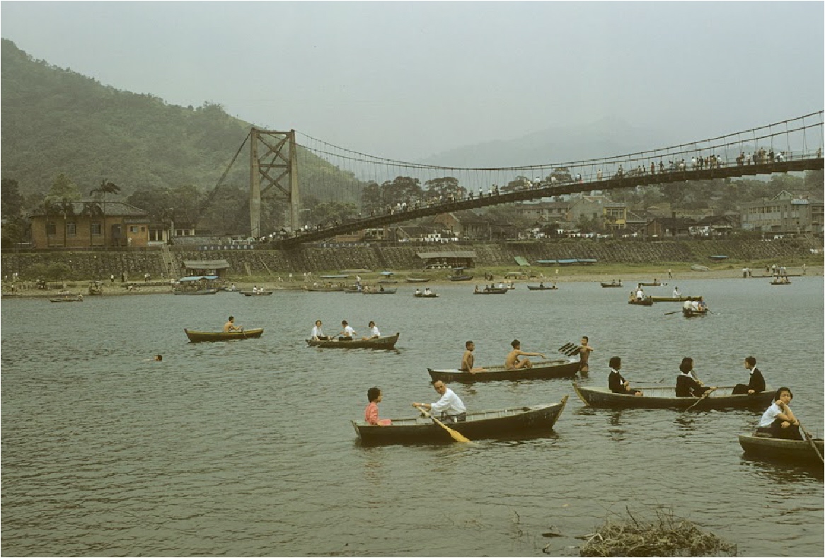
 Almost south of Taipei is a lake which provides a relaxing and peaceful break from the craziness of the bustling downtown area of Taipei.  Bitan Lake, known to us as Green Lake, is situated in the Xindian District in the extreme southern part of Taipei.   

It appears to be right on the Xindian River.  To check for yourself, here are the coordinates for Google Earth.  24 57'26.06"N, 121 32'09.47"E.

Many pictures have been taken of the area over the decades, but probably the best ones are in a section of taipics.com which can be seen by clicking HERE

A modern-day collection of pictures of the lake can be seen at Kent Mathieu's taipeiairstation.blogspot.com.  You can view Kent's collection by clicking HERE


Fortunately, my little guide book contained a page on Pitan Lake. The time period here is 1966.

Photo courtesy of Tom Jones

Although this photo of Green Lake is over 50 years old, it appears as though it could have been taken today.
Photo courtesy of Tom Jones


One of the unique features of Bitan Lake is the pedestrian suspension bridge. If this photo were a painting, it could be a Courier and Ives. It's perfect. 
Photo courtesy of Tom Jones

The mountains in the background provide a beautiful view along the Xindian River area. 
Photo courtesy of Tom Jones


This is a coal mine located near the lake itself.

Jason Chen gave permission to show his stacking of Tom Jones' picture with his own present-day photo of the same area.
Photo courtesy of Tom Jones

This is simply a picture of a boat transporting folks.

Again, Jason Chen has taken Tom's 1957 photo and stacked it with a 2012 picture. Whatever Jason has circled is unknown.

Friday, November 9, 2012

Living In Taipei, 1957-58

10 years before our group of draftees arrived in Taiwan, U S military men were told they HAD to live in non-government housing. Our bunch would have cheered at that news.

Not that the barracks at the Grass Mountain facility were terrible, nor was the food at the mess hall inedible. It was the 10 miles from Taipei that cramped many lifestyles.  

Let's hope that Tom and his friends received an extra allotment for their living arrangements. Tom wrote that the best thing about cooking and eating locally was the ultimate result of strengthening his immune system.


Photo courtesy of Tom Jones

One of these apartments is where Tom lived during his Taipei days. Decades later a commenter on this picture told Mr. Jones where he thought his address was


Lane 55, Section 3, Chung Shan (Zhongshan) North Road just south of Min Tsu (Minzu) East Road. That's the address he was given, and the red line indicates its location.

In 1968, Min Tsu East was a narrow paved road that consisted mainly of foot traffic and motorcycles. In 1957, it probably wasn't paved and the same might have been true of Min Tsu West Road.

Minzu East ran directly beside the entrance to the Signal Compound.


The apartments were on the south side (right side) of the lane. The building at the left is on the southeast corner of Minzu East and Zhongshan North Roads.  

The photo below is this same area in 1957-58 except it iis flip-flopped horizontally, with the apartments on the left..


Photo courtesy of Tom Jones

 
This is Lane 55, with the apartments on the left (south side) of the lane.  On the right is a large ditch which is in front of Min Tsu East Road. 

Chung Shan North Road is at the top of this picture.  The children are on their way to Chung Shan Elementary School.

 
Photo courtesy of Tom Jones

This is part of the PSD compound. It was not far from where Tom lived. My guess is that this was the beginning phase of the Signal Compound construction.

 
Photo courtesy of Tom Jones

It doesn't look like an organized collection of communication buildings, but construction went very quickly in this area in the 1950s and 60s. 
Photo courtesy of Tom Jones

This certainly looks like a baseball or softball field.  It is labeled as USCD. Again, my thoughts say that this is what became known as Pacer Field..

Photo courtesy of Tom Jones

So, now we know.  This is the construction area of the Navy Commissary in 1957.  If it is near us in this picture, what is the building across from it?  Somebody has to know.

Photo courtesy of Tom Jones

It certainly looks like Chung Shan North Road and it is. 

One of the commenters on this photo indicated that the large building on the left is MacKay Memorial Hospital which was located at Section 2, 92 Zhongshan North Road.
Photo courtesy of Tom Jones


This picture shows the main means of travel within the city at that time.  Buses and pedicabs were plentiful.  Trains were available, but not always convenient.

Photo courtesy of Tom Jones

Enjoying his ride in a pedicab is Don Ranck.  The comments on this picture were more inspired by the beautiful American car in the background. Pedicabs were outlawed by the time we arrived in 1968. 

A mammoth project had taken place as many of the displaced pedicab drivers were educated on how to maneuver a taxi.  Hundreds of red Datsun Bluebirds, made by Nissan, flooded the streets of Taipei. 

Horns blared, tires squealed, gears ground and fenders clashed.  The transition was the Taiwan equivalent of Social Darwinism.  The best of these new drivers continued to earn a living behind the wheel.  The worst sorted themselves out, one way or another.   
Photo courtesy of Tom Jones

Is this really a portable ice cream wagon?
Answer:  Yes, it is!
Photo courtesy of Tom Jones

Here is the pool of the Club 63.  We have no pictures of the front of the club itself. 
Photo courtesy of Tom Jones

The Club 63 NCO pool, shot from the opposite end of the picture above.