10 years before our group of draftees arrived in Taiwan, U S military men were told they HAD to live in non-government housing. Our bunch would have cheered at that news.
Not that the barracks at the Grass Mountain facility were terrible, nor was the food at the mess hall inedible. It was the 10 miles from Taipei that cramped many lifestyles.
Let's hope that Tom and his friends received an extra allotment for their living arrangements. Tom wrote that the best thing about cooking and eating locally was the ultimate result of strengthening his immune system.
 |
| Photo courtesy of Tom Jones
One of these apartments is where Tom lived during his Taipei days. Decades later a commenter on this picture told Mr. Jones where he thought his address was
|
 |
| Photo courtesy of Tom Jones |
This is Lane 55, with the apartments on the left (south side) of the lane. On the right is a large ditch which is in front of Min Tsu East Road.
Chung Shan North Road is at the top of this picture. The children are on their way to Chung Shan Elementary School.
 |
| Photo courtesy of Tom Jones
This is part of the PSD compound. It was not far from where Tom lived. My guess is that this was the beginning phase of the Signal Compound construction.
|
| Photo courtesy of Tom Jones
It doesn't look like an organized collection of communication buildings, but construction went very quickly in this area in the 1950s and 60s.
|
 |
| Photo courtesy of Tom Jones
This certainly looks like a baseball or softball field. It is labeled as USCD. Again, my thoughts say that this is what became known as Pacer Field..
|
| Photo courtesy of Tom Jones
So, now we know. This is the construction area of the Navy Commissary in 1957. If it is near us in this picture, what is the building across from it? Somebody has to know.
|
| Photo courtesy of Tom Jones
It certainly looks like Chung Shan North Road and it is.
One of the commenters on this photo indicated that the large building on the left is MacKay Memorial Hospital which was located at Section 2, 92 Zhongshan North Road. |
| Photo courtesy of Tom Jones
This picture shows the main means of travel within the city at that time. Buses and pedicabs were plentiful. Trains were available, but not always convenient.
|
| Photo courtesy of Tom Jones
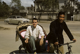
Enjoying his ride in a pedicab is Don Ranck. The comments on this picture were more inspired by the beautiful American car in the background. Pedicabs were outlawed by the time we arrived in 1968.
A mammoth project had taken place as many of the displaced pedicab drivers were educated on how to maneuver a taxi. Hundreds of red Datsun Bluebirds, made by Nissan, flooded the streets of Taipei. Horns blared, tires squealed, gears ground and fenders clashed. The transition was the Taiwan equivalent of Social Darwinism. The best of these new drivers continued to earn a living behind the wheel. The worst sorted themselves out, one way or another. |
 |
| Photo courtesy of Tom Jones Is this really a portable ice cream wagon? Answer: Yes, it is! |
 |
| Photo courtesy of Tom Jones
Here is the pool of the Club 63. We have no pictures of the front of the club itself.
|


>the large building on the right is MacKay Memorial Hospital
ReplyDeleteI believe the large building on the LEFT in the eighth photo is the Mackay Memorial Hospital. The photo is facing north(please see the shadows on the ground and the hills in the background) and the hospital is on the western side of Zhongshan North Road.
And yes, the vendor in the eleventh photo is indeed selling his ice cream. Tom may find several amazing flavors such as redbean, longan, taro, or even sour plum.
Mackay Hospital was further south on Chungshan Rd. Guanyin Mtn in the background shows the view is north west.
DeleteI believe the long building behind the Navy Commissary in photo 8 is the rear of the FASD hostels that were just north of the East and West compound gates of Chung Shan North Road. The structure on the south (left) end of the roof looks like the one in the photo I from 1968 when I was there.
ReplyDeleteNow, that makes sense. If Tom and his co-workers were living with the locals, the hostel had not yet been built. Thanks
ReplyDeletePfc Ciccarello USARSCAT station down town in sugar buld.from4/62 to 8/63 housed behine PX.
ReplyDeleteMy dad ran the commissary from 1957 to 1959. My brother Harry and I lived in military housing near the commissary (kinda behind it) and used to walk across the street to swim at the O Club Pool. Both of us attended the Taipei American School and my mom taught 7th grade English. Thanks for sharing your pix and info.
ReplyDeleteMark Baker, San Diego, CA