USASTRATCOM

This blog was created for USASTRATCOM Long Lines Battalion Army personnel who served in Taiwan during the 1965-72 time frame. Specifically, those who lived and worked in and around Taipei are the target. If you worked at the Grass Mountain or Gold Mountain facilities or anywhere in downtown Taipei, we would like to hear from you. All are welcome to visit and contribute to this blog. Your comments and pictures are encouraged.

Thursday, November 15, 2012

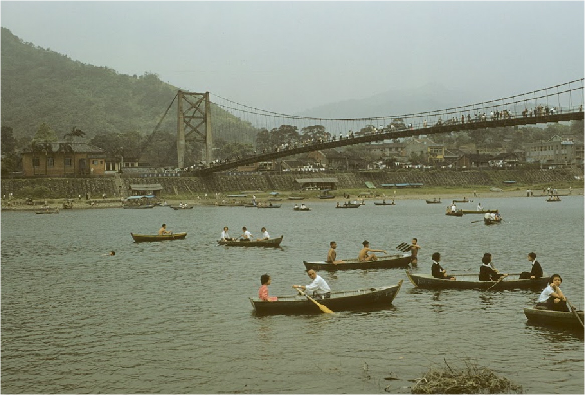
Green Lake, Taipei, Taiwan, 1957-58

 Almost south of Taipei is a lake which provides a relaxing and peaceful break from the craziness of the bustling downtown area of Taipei.  Bitan Lake, known to us as Green Lake, is situated in the Xindian District in the extreme southern part of Taipei.   

It appears to be right on the Xindian River.  To check for yourself, here are the coordinates for Google Earth.  24 57'26.06"N, 121 32'09.47"E.

Many pictures have been taken of the area over the decades, but probably the best ones are in a section of taipics.com which can be seen by clicking HERE

A modern-day collection of pictures of the lake can be seen at Kent Mathieu's taipeiairstation.blogspot.com.  You can view Kent's collection by clicking HERE


Fortunately, my little guide book contained a page on Pitan Lake. The time period here is 1966.

Photo courtesy of Tom Jones

Although this photo of Green Lake is over 50 years old, it appears as though it could have been taken today.
Photo courtesy of Tom Jones


One of the unique features of Bitan Lake is the pedestrian suspension bridge. If this photo were a painting, it could be a Courier and Ives. It's perfect. 
Photo courtesy of Tom Jones

The mountains in the background provide a beautiful view along the Xindian River area. 
Photo courtesy of Tom Jones


This is a coal mine located near the lake itself.

Jason Chen gave permission to show his stacking of Tom Jones' picture with his own present-day photo of the same area.
Photo courtesy of Tom Jones

This is simply a picture of a boat transporting folks.

Again, Jason Chen has taken Tom's 1957 photo and stacked it with a 2012 picture. Whatever Jason has circled is unknown.

Friday, November 9, 2012

Living In Taipei, 1957-58

10 years before our group of draftees arrived in Taiwan, U S military men were told they HAD to live in non-government housing. Our bunch would have cheered at that news.

Not that the barracks at the Grass Mountain facility were terrible, nor was the food at the mess hall inedible. It was the 10 miles from Taipei that cramped many lifestyles.  

Let's hope that Tom and his friends received an extra allotment for their living arrangements. Tom wrote that the best thing about cooking and eating locally was the ultimate result of strengthening his immune system.


Photo courtesy of Tom Jones

One of these apartments is where Tom lived during his Taipei days. Decades later a commenter on this picture told Mr. Jones where he thought his address was


Lane 55, Section 3, Chung Shan (Zhongshan) North Road just south of Min Tsu (Minzu) East Road. That's the address he was given, and the red line indicates its location.

In 1968, Min Tsu East was a narrow paved road that consisted mainly of foot traffic and motorcycles. In 1957, it probably wasn't paved and the same might have been true of Min Tsu West Road.

Minzu East ran directly beside the entrance to the Signal Compound.


The apartments were on the south side (right side) of the lane. The building at the left is on the southeast corner of Minzu East and Zhongshan North Roads.  

The photo below is this same area in 1957-58 except it iis flip-flopped horizontally, with the apartments on the left..


Photo courtesy of Tom Jones

 
This is Lane 55, with the apartments on the left (south side) of the lane.  On the right is a large ditch which is in front of Min Tsu East Road. 

Chung Shan North Road is at the top of this picture.  The children are on their way to Chung Shan Elementary School.

 
Photo courtesy of Tom Jones

This is part of the PSD compound. It was not far from where Tom lived. My guess is that this was the beginning phase of the Signal Compound construction.

 
Photo courtesy of Tom Jones

It doesn't look like an organized collection of communication buildings, but construction went very quickly in this area in the 1950s and 60s. 
Photo courtesy of Tom Jones

This certainly looks like a baseball or softball field.  It is labeled as USCD. Again, my thoughts say that this is what became known as Pacer Field..

Photo courtesy of Tom Jones

So, now we know.  This is the construction area of the Navy Commissary in 1957.  If it is near us in this picture, what is the building across from it?  Somebody has to know.

Photo courtesy of Tom Jones

It certainly looks like Chung Shan North Road and it is. 

One of the commenters on this photo indicated that the large building on the left is MacKay Memorial Hospital which was located at Section 2, 92 Zhongshan North Road.
Photo courtesy of Tom Jones


This picture shows the main means of travel within the city at that time.  Buses and pedicabs were plentiful.  Trains were available, but not always convenient.

Photo courtesy of Tom Jones

Enjoying his ride in a pedicab is Don Ranck.  The comments on this picture were more inspired by the beautiful American car in the background. Pedicabs were outlawed by the time we arrived in 1968. 

A mammoth project had taken place as many of the displaced pedicab drivers were educated on how to maneuver a taxi.  Hundreds of red Datsun Bluebirds, made by Nissan, flooded the streets of Taipei. 

Horns blared, tires squealed, gears ground and fenders clashed.  The transition was the Taiwan equivalent of Social Darwinism.  The best of these new drivers continued to earn a living behind the wheel.  The worst sorted themselves out, one way or another.   
Photo courtesy of Tom Jones

Is this really a portable ice cream wagon?
Answer:  Yes, it is!
Photo courtesy of Tom Jones

Here is the pool of the Club 63.  We have no pictures of the front of the club itself. 
Photo courtesy of Tom Jones

The Club 63 NCO pool, shot from the opposite end of the picture above.

Thursday, November 1, 2012

The Signal Corps In Taiwan, 1957-58

By the beginning of the Korean War, it became apparent to the U.S. that Taiwan was a major asset in the Western Pacific.  Thousands of Americans began to be assigned to Taiwan as part of our commitment to the future existence of the ROC.

The following posts are possible because an Army Signal Corps soldier took the time to chronicle his Taiwan tour of duty in 1957-58. By then the downtown area of Taipei and other major Taiwan cities were beginning to change. 

Tom Jones was with the Provisional Signal Detachment (PSD) which began linking various parts of Taiwan together.  He arrived from the U.S. as an E4 with an MOS of Fixed Station Transmitter Repair Instructor.  To me, that means he was trained at Ft. Monmouth, New Jersey. 

Tom has given our blog the privilege of using some of his 250+ pictures which he took during his deployment.  Fortunately for us, he used 35mm slides which make these old pictures look as though they had just been taken yesterday. 

My friend and TSA blog contributor, Gary Roske, sent me the link to these pictures.  Then I came across a posting by USTDC blogger, Don Wiggins.  It is the same link as Gary's and can be seen by clicking   HERE.  It can be found at Don's blog dated September 21, 2012.

Mr. Jones' photos have been sorted into groups by me which roughly follow Tom's tour of duty in Taiwan.  He has ultimate say over what is being published, so some of these may be changed. 

In this post, all of the photos were taken by Tom.They are being shown with the consent of Tom Jones.  They are protected by his copyrights. Any other photos that may be used will be identified accordingly. 

Photo courtesy of Tom Jones
 
This is The Oakland Army Base, also know as The Oakland Army Terminal.  It was a prime piece of real estate from which materials and military personnel were shipped to the Pacific starting in WWII, then Korea, and Viet Nam. 

Located near the San Francisco-Oakland Bay Bridge, the base began its mission in 1942 and continued as part of the military effort until its eventual closing in 1999.


Photo courtesy of Tom Jones
 
This looks like the process in-process out building.  Imagine how many thousands passed through its doors throughout the decades. 


Photo courtesy of Tom Jones
Here is Tom during a Tokyo layover in 1957. 

Photo courtesy of Tom Jones

This is the last view of Taipei that Tom took in 1958. We will just turn the plane around and call it the first view one would have of the Taipei skyline in 1957.
Photo courtesy of Tom Jones

 With the Keelung River in the middle of the picture, just look up from it and you will see Taipei International Airport in 1957.


Photo courtesy of Tom Jones

 
Taken from downtown and looking eastward, you can see the main runway of what was to us, Taipei International Airport.  

The IATA. letters were TPE which now belong to the new Taiwan Taoyuan International Airport, south of Taipei. The new name of the airport in Taipei is Songshan Airport (TSA).


Photo courtesy of Tom Jones

 
This one of many photos Tom took of the Keelung River which connects with the port city of Keelung.

Photo courtesy of Tom Jones

 
Here is a 1958 shot of the mouth of the Tamsui River which flows south into Taipei from its northernmost location. 

Photo courtesy of Tom Jones

This is the same view in 2012 of the picture shown above. I don't believe Tom took this one. 

Wednesday, October 17, 2012

228 Peace Park, Taipei, Taiwan

After WWII, the Japanese government was ordered to relinquish all of its holdings in Taiwan. It's 1945, and the Allies were the victors. Chiang Kai-Shek claimed Taiwan as part of the Republic of China.

The irony of this Peace Park is its genesis. The Kuomintang political party of the ROC had to deal with an uprising beginning February 27, 1947.

There is no need for a history lesson, but, the takeover of Taiwan by the ROC didn't go smoothly. Click this to read about Taiwan and the Kuomintang after WWII. 

Click HERE  to read the Taiwanese version of its history. For an even more concise version, click this text.

There was no intention of putting a damper on the subject of the 228 Peace Park, but Taiwanese historians would want, I sincerely believe, all visitors and tourists to know its bloody background.

This day is as important to the Taiwanese as our Memorial Day is to us in the US. My friend, VWC will, I'm sure, correct any errors made by me.

With that introduction, let me say that my good friend Kent Mathieu is to be given all the credit for these new 228 Peace Park photos. His walking tour videos and still pictures have helped  me tell a strory many times.

Back in 1969, my wife and I had visited this area a few times and had taken several pictures. Since Kent was in Taipei earlier this year, I had asked him to take a few photos so a "then and now" posting could be made.

Below are some old pictures we took, along with the rest of the pictures which were all taken by Kent .


This park was a very serene place back in 1969.

We never went into this building.


Today, this is the National Taiwan Museum.


The National Taiwan Museum is the oldest museum in Taiwan. Why the Japanese built it in the Greek Revival style is a mystery.


Just follow the arrow of your choice.

Here we are.

Here is the park today. The old Longevity Park is at the upper left and the National Taiwan Museum is at the bottom. The picture is from Wikipedia. A band shell, fountain and sculpture are a few of the newer sites within the park.

Me on a bridge near the National Taiwan Museum in 1969

Here is the same bridge today. Kent really did a great job of recreating the angle. Notice the steps that have been added. Sorry, rollerbladers

A pagoda and pavilion in 1969

Again, a great duplication by Kent in 2012

These two railroad engines were covered from above, but were otherwise exposed to the elements.

Glass surrounds the new enclosure.

At the opposite end are two signs explaining the history of the two locomotives.

The new preservation effort is a success, I'd say.

Sunday, September 30, 2012

Major Betty's, Taipei, Taiwan

For all of us who believe in the of freedom to establish a business with very little government interference, Major Betty's was the pinnacle of this economic philosophy.

Not only was she an independent contractor and mentor to many, but she also eluded the tax people for years.

If she had been a politically active American, her party of choice would have been the Libertarian. If not, she would have been an Independent.

Unfortunately, we have no pictures to confirm her palace of pleasure, nor do we have an exact location from which she plied her expertise.

Maybe that's the way it should be. The place was part myth, part legend and wholly owned by a sole proprietor.

Most of us knew the location simply as "down there" or "near this place."

Regardless, if a person wished to find her office, it certainly wasn't hard.

We can all agree, I believe, that  this institution had a rich oral history.


Not all of Taipei's nighttime fun was limited to the area near the Chung Shan and Min Chuan intersection.  Linsen North Road was quite familiar to many of us who bounced around downtown.

Linsen North is actually a shortcut for the clever cab driver. It begins way downtown and runs north next to Chung Shan North Road until it dead ends at the Min Tsu East Road intersection.

The Google Earth maps of today showing this area very much coincide with the great maps of 1970 that can be found on Dawgflight.com/Taipei Nightlife I and II.

Just click  this link and look for yourself. If you like maps, you will have hit the jackpot.


We are looking north across Min Chuan East Road.  Above us, and all around the intersection is the pedestrian overpass which is still used today.

It crosses over Min Chuan East Road and Linsen North Road. 

That primary school on the right was there in 1970 and still takes up a considerable amount of real estate east and north of this vantage point.  It makes sense to have a secure walkway to the school.

On the previous post, the day and night photos of downtown Taipei were taken from the bridge across Min Chuan East Road. 


As the stairway comes down on the east side of Linsen North Road, the wall around the primary school can be easily seen. 

The buildings on the left seem to be mostly new.  


As the road progresses northward, the murals on the walls surrounding the primary school show how large this educational area was, and still is. 


Photo by Carpenter 1970; Courtesy of Dawgflight.com

An alley marks the end of the school.  In 1970, this picture of the Union Hotel shows what was standing directly on the other side of the alley. 

It was a fairly new hotel in 1968.  Our Grass Mountain NCOIC and his family stayed there until their house in Tien Mou was ready for residency. 


It is easier today to see how the wall surrounding the school stops at the alley.  On the other side of the alley where the Union Hotel once stood is a hospital. 

After my checking with the foremost experts in Taipei architecture, the consensus seems to be that the building we see is not the basic Union Hotel with many many additions to it. 

So, here is the hospital and a direct view east. This alley (lane) and all streets heading east in this area led eventually to a locally famous benjo ditch back then.

Eventually, crossing this ditch led to a commercial area full of goods and services and services for sale.  

For those of you familiar with this area at one time, the change to it is impressive. This is the Nongan Street intersection.

Turning left leads to the Florida Bakery near the Chung Shan North Road intersection.

Turning right led to the ditch in the 1960s, but now a right turn offers a few surprises.

This is Nongan Street heading east near the present-day overhead expressway.

What we have is a 24 hour hotel. Yes, check in and out at any time, any day. I'm told that this is a perfectly innocent convenience of a legitimate hotel.

In our Taipei days, there were many of these short-term rests for the weary.  Some rented by the hour or a little more. Whether the linen, sheets and pillow cases were changed was a different story.


Continuing north, we approach the familiar Imperial Hotel on the left.

The Imperial was a going concern in 1968, but was not included on the list of recommended hotels in the 1967 guide book used many times in this  blog.

It was also off-limits to those on R and R.
Today, however, it is rated as a 4-Star hotel by some travel agencies.


The lanes on either side of the Imperial lead to many bars and pubs. Whether the difference in names today is of any practical significance I don't know.

Back in the Vietnam War years, there certainly was a profound difference when an establishment called itself a bar or a club.

Continuing north, on the east side of Linsen is a tailor shop touting its quality.

The temple on the northwest corner signifies the approach to the Dehui Street intersection.

After passing through this intersection, we are getting closer to the area made famous by The Major.

It's one of the three alleys remaining on the left (west) side of Linsen North Road.

This is alley A which runs behind what once was the President Hotel and the old temple.

Next is alley B which might have been just another lane. This and the other 2 lanes can be traveled using Google Earth Street View.

Finally we pass alley C which, today, is just south of the Riviera Hotel. The hotel wasn't there in the 1960s.

The Riviera stands at the corner of Linsen North Road and Min Tsu East Road.

The gate across the street is at the approximate entrance to the old Signal Compound.

Back in 1968-69, Min Tsu East Road was a two lane street that was not heavily traveled. Its widening began in the summer of 1969.

So, was it located near alleys A, B, or C.?

Maybe it was situated somewhere else, or headquarters may have been constantly changing to avoid the intangible tax.

If you would like to participate, perhaps we can get it nailed.

First, you might want to check a 1970 map at the Dawgflight link above.

Then send an anonymous comment indicating your vote. All legitimate comments will be welcomed.

Don and Kent have posted some remarkable topics and have gotten little or no response in the form of a comment.

Now is the opportunity to take a little time and give us the skinny!